PHOTO
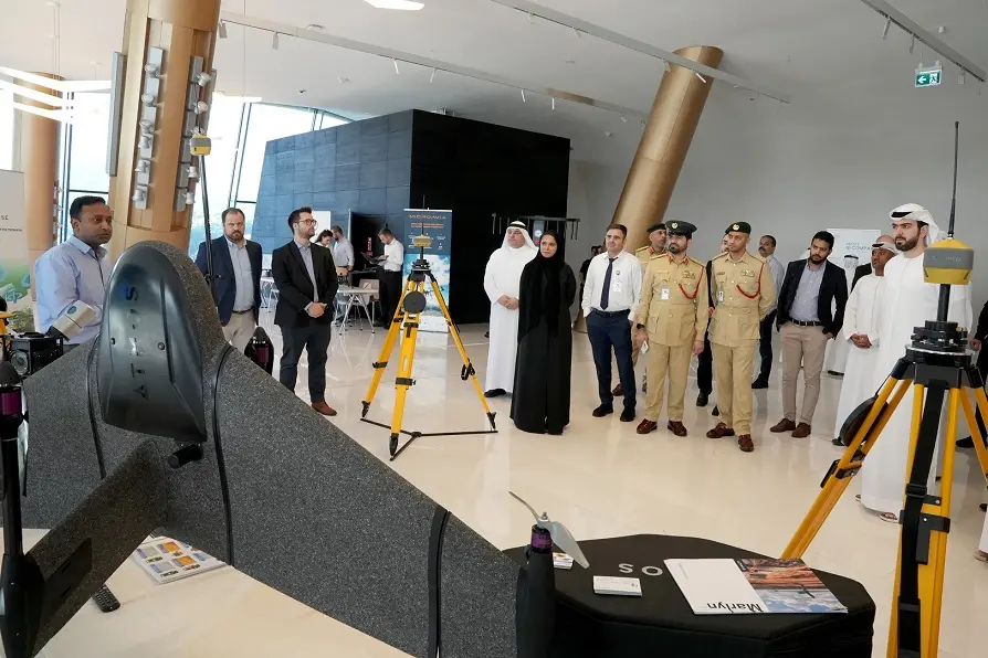
Dubai, UAE: Dubai Municipality’s Geographic Information Systems Department commemorated World Geographic Information Systems Day, an annual event hosted on November 16, at the Union Museum. The event witnessed the participation of nearly 100 representatives from local, government, semi-governmental, and private entities in Dubai. Through this event, the Municipality reaffirmed its vital role in managing and developing Geographic Information Systems in the Emirate, considering its relevance in the process of decision-making, crisis management, urban planning, map production, infrastructure development and building an efficient community. Additionally, the celebration aligns with the vision of Dubai Government to become one of the most future-ready cities.
The event provided a dynamic platform for various constructive discussions, which aimed at improving the capabilities of the field of Geographic Information Systems, developing innovative technologies to support the system infrastructure, and creating new research horizons. Additionally, the event looked at possibilities of using geospatial capabilities to address climate change phenomena and designing mitigation strategies. The move is in line with Dubai and the UAE's goals of becoming carbon neutral and expanding their global involvement in sustainability and environmental initiatives. It also coincides with Dubai hosting the 28th Conference of the Parties to the United Nations Framework Convention on Climate Change (COP28).
During the event, Mariam Al Muhairi, CEO of the Buildings Regulation and Permits Agency at Dubai Municipality, highlighted the Municipality's continued efforts to develop a comprehensive and integrated geospatial system for the Emirate. The key goal of these efforts is to secure a digital twin and create an exact digital replica of the city, bolstering its digital excellence and leading position in this realm. Geospatial systems hold immense potential to support various urban planning procedures and play a remarkable role in various advanced infrastructure projects.
Eng. Al Muhairi said: “The Geographic Information Systems Center of Dubai Municipality is recognized both regionally and internationally for its capacity to provide geospatial services leveraging state-of-the-art global technologies for data collection and analysis,”
“Dubai Municipality has carried out several ground-breaking geospatial projects through its Geographic Information Systems Centre to improve infrastructure services and develop Dubai's urban environment. The use of artificial intelligence (AI) to identify building infractions, Dubai Horizons, 3D infrastructure utility maps, digital twins in Dubai, and building information modelling are some of the noteworthy projects. The municipality has created an array of cutting-edge tools and software to provide proactive, comprehensive government services that improve user experiences. It also consistently makes investments in developing geospatial systems that include precise and current data on Dubai's public services and infrastructure,” Al Muhairi added.
Continuous efforts
Through implementing various initiatives and activities, Dubai Municipality is relentlessly working to develop and boost the geospatial information field as well as to reinforce the pioneering position and competitiveness of the Emirate in this realm. The Municipality’s efforts include research, innovation and the development of interactive applications and solutions to improve various services for businesses. Furthermore, Dubai Municipality works to strengthen its partnerships with governmental bodies and the private sector to promote the exchange of geographic data and information. It has also designed training and awareness programs for the workforce and the community to raise awareness on Geographic Information Systems (GIS), its significance and vital role in the planning procedures.
Local and international achievements
Additionally, Dubai Municipality has secured numerous local and international recognitions in the field of Geographic Information Systems. These achievements, along with elevated collaborations international institutions has helped Dubai to reinforce its pioneering position in the field. It also received an array of international awards and recognitions, demonstrating its standing and leadership in geographic systems.
For further information, please contact:
Orient Planet Group (OPG)
Email: media@orientplanet.com
Website: www.orientplanet.com