PHOTO
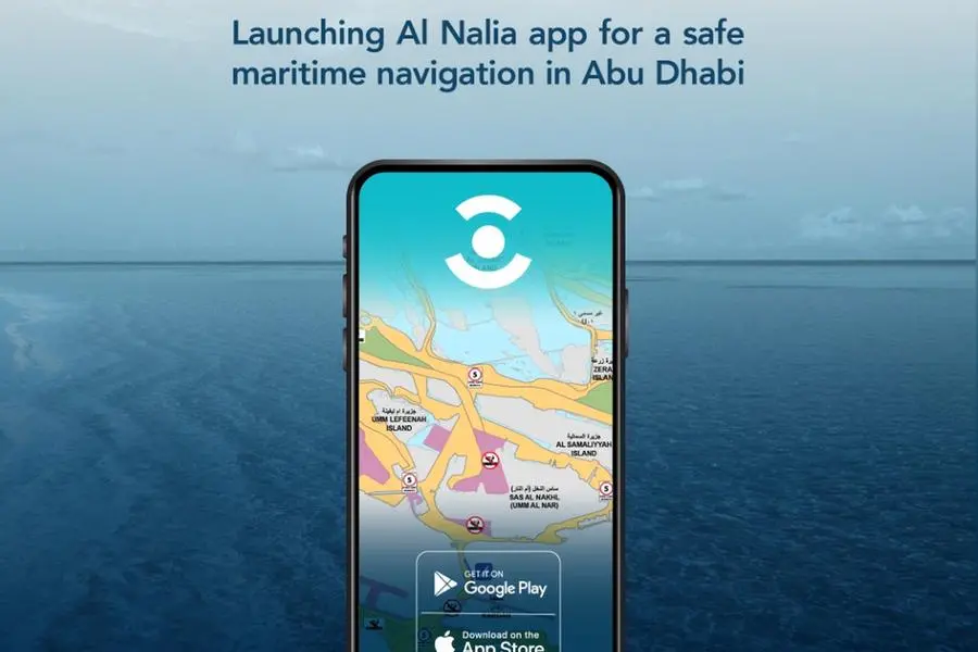
The Department of Municipalities and Transport (DMT) has announced the launch of a new smartphone application called Al Nalia, which provides access to maritime safety maps for Abu Dhabi. The app was developed in collaboration with Abu Dhabi Maritime and Maqta Gateway, both part of the AD Ports Group, and is designed to enhance the safety of marine navigation in the emirate. It also ensures the efficiency and ease of use of waterways in Abu Dhabi.
Al Nalia has been introduced as a follow-up to the launch of the Maritime Safety Maps in Abu Dhabi. Both launches represent a qualitative shift in maritime navigation in the emirate by displaying important navigational information in real-time. This includes major commercial transit lanes and connectivity routes, speed limits, mooring and anchorage areas, and designated locations for motorised and non-motorised recreational maritime activities.
The app has a highly interactive interface that enables users to search directly for the nearest marine facilities, such as marinas, slipways, and marine fuel stations. It also identifies locations designated for recreational activities, including jet skis, marine water sports, swimming, and surfing.
The app has been named after the historical maps used by UAE's ancestors for navigating local waterways, which marked information about the harbour and pearl diving sites. The name Al Nalia is a tribute to the legacy and depth of sailing history in the UAE.
The application offers users one of the region's most advanced maritime navigational services for smartphones, providing a flexible experience that ensures ease of use and navigation. It delivers accurate data directly on global navigation systems such as Google Maps, helping users identify the best waterways, routes, and destinations, thereby making maritime map reading more accessible and user-friendly than ever before.
The Al Nalia mobile app, developed by Maqta Gateway, the digital arm of AD Ports Group, provides users with access to additional features that are conveniently and easily accessible. The app can be downloaded from the App Store and Google Play, while the Maritime Safety Maps are available on Abu Dhabi Maritime's digital portal. The interactive maps display users' location in real-time and provide information on any regulations within their current zone, ensuring the safe and proper usage of waterways for all residents and visitors to the emirate.
Dr. Salem Khalfan Al Kaabi, Director-General of Operational Affairs at DMT, said that the new application significantly contributes to promoting digital transformation and enhances Abu Dhabi's status as a world-leading maritime hub.
Mohamed Juma Al Shamisi, Managing Director and Group CEO of AD Ports Group, stated that the introduction of new digital solutions, such as the Al Nalia application, reflects the company's commitment to innovation and the creation of a robust national economy. The app pushes the boundaries of how advanced technology can be applied to modernizing service capabilities and enhancing the user experience of the maritime community while strengthening Abu Dhabi's position as a leading global maritime center.
Saif Al Mheiri, Managing Director of Abu Dhabi Maritime at AD Ports Group, noted that the Al Nalia app is a key milestone in Abu Dhabi Maritime's continued collaborative efforts to develop groundbreaking solutions that accelerate the digitalisation of the emirate's maritime industry. The app overlays Abu Dhabi's navigational maps with zoning and safety regulations in a fully interactive format, greatly elevating the level of navigational security and efficiency across the emirate's waterways for both commercial and recreational users.
The Maritime Safety Maps were developed in close collaboration with Abu Dhabi Maritime, Maqta Gateway, Environment Agency – Abu Dhabi (EAD), Department of Culture and Tourism (DCT), Abu Dhabi National Oil Company (ADNOC), and the Critical Infrastructure and Coastal Protection Command (CICPC).