PHOTO
Typhoon Mawar roared over the US territory of Guam on Wednesday, bringing destructive winds to the Pacific military outpost.
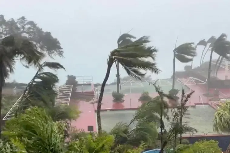
The eye of the storm passed just north of the island, its governor said, after forecasters had warned that winds of up to 140 miles per hour (225 kilometers per hour) could cause major damage.
"What we are feeling right now is the eye going over the Rota Channel," Governor Lou Leon Guerrero said in a Facebook video, referring to the body of water between the islands of Guam and Rota.
Local authorities earlier issued evacuation orders and opened temporary shelters, while US President Joe Biden declared a state of emergency for the island of 170,000 people, paving the way for federal aid.
"I am in a concrete-reinforced house and my windows are shuttered. I did go outside briefly and winds are getting very gusty with intermittent rains," Beckie Merrill, a 46-year-old middle school teacher, told AFP from a southern area of the island.
After predicting a "direct hit" on Guam, forecasters later said the typhoon had moved just north of the island.
"It looks like we are getting a near hit with the eye passing through the Rota Channel. The southern wall of the eye will pass over much of Guam. The worst winds will be in the northern third of Guam," the US National Weather Service (NWS) told AFP.
Warnings of extreme winds and flash floods have been issued for Guam, with the Office of Civil Defense cautioning that "widespread destructive winds of 115 to 140 mph" were moving over northern areas of the island.
"I am worried for the safety of our people. This is the first storm of this magnitude for 20 years," Guerrero said.
- Coastal evacuations -
Evacuations were ordered for low-lying coastal areas, especially in the flood-prone southern villages.
The NWS warned of the "triple threats" of torrential rain, catastrophic winds and a life-threatening storm surge.
Winds near the eye wall could bring major damage to buildings and homes made of light materials such as non-concrete roofs and walls not made of reinforced concrete.
A calamitous storm surge threatens to wreak havoc on shorelines, and large boats "could be torn from moorings."
"Surge may reach to between 20 and 25 feet above normal high tide for the most vulnerable storm-surge-prone areas near the eye wall," the NWS said.
Forecasts predicted Guam will receive rainfall of 10 to 15 inches, with some areas seeing 20 inches or more, the NWS said.
This could trigger landslides in the central and southern parts of the island, the weather service warned.
- 'Frightening' -
"Many of us right now are feeling the full strength of Typhoon Mawar, and although it is a frightening experience that hasn't been felt for over two decades, we want you to know that we are here for you," Guerrero said in a Facebook post.
"Even as the typhoon makes its initial landfall, we have multiple agencies coordinating response efforts and relaying helpful information to those in need."
People were told to stay inside and away from windows, and not venture outside during temporary lulls as flying debris can cause serious injury.
About 21,700 US military personnel and their families are based at or near several facilities on Guam, which routinely hosts nuclear attack submarines and long-range bombers.
The territory is also home to crucial electronic listening posts.
The US bases have some of the Pacific region's most significant ammunition and fuel storage facilities.
About 60 flights scheduled to depart or arrive in Guam between Tuesday and Thursday were canceled, A.B. Won Pat International Airport said.
Conditions in Guam are expected to improve on Thursday, but the storm is expected to intensify over the next few days, possibly becoming a super typhoon over the Philippine Sea, the NWS said.