Lootah calls for popularizing the use of GIS
Eng. Hussain Nasser Lootah, Acting Director General of Dubai Municipality said the need for using Geographic Information System (GIS) and remote sensing techniques is severely felt in the Middle East countries due to the existence of abundant natural resources and the necessity for planning and managing those resources for effective use and also because of the rapid development.
He was delivering the opening address at Map Middle East 2007, the 3rd Annual Conference and Exhibition on GeoSpatial Information, Technologies and Applications at the Sheikh Maktoum Hall of Dubai International Convention and Exhibition Centre.
The event, held under the patronage of the Deputy Ruler of Dubai, UAE Minister of Finance and Industry and Chairman of Dubai Municipality Sheikh Hamdan Bin Rashid Al Maktoum, will last until Wednesday.
Lootah said the economic dimension of GIS is more an opportunity than a challenge.
"The opportunities lie in the use of skills in GIS and its infrastructure via satellites which can help us to get a share of the global market. We must be able to make use of the infrastructure already developed by us in terms of technology on the one hand and more important the technical skills we have created on the other so that the GIS can become a major source of development," he said.
"Today, in the Middle East region and especially in cities like Dubai, Geospatial technologies are not only the objectives of governance but are the drivers in the development of the cites themselves.
The conference organized by Dubai Municipality in cooperation with GIS Development, with the theme, "GeoSpatial Convergence - The Next Step," embraces all aspects of geospatial technologies and their applications.
Mohammed Al Zaffin, Chairman of the Organizing Committee of Map Middle East 2007 and Director of Dubai GIS Centre, who delivered the welcome speech, said the region was and has continued to be the focus of attention for application of innovation in geospatial domain.
"The large scale urban infrastructure developments taking place in this region calls for the increased usage of geospatial technology, in association with the other vertical engineering segments like civil, electrical and regional planning," said Zaffin, quoting the example of Burj Dubai, which is using GPS network to monitor the building vertical alignment in a classical and novel way setting an example globally.
Sanjay Kumar, CEO of GIS Development, said increasing demand of geospatial information has also brought forward certain degree of new challenges to survey and mapping agencies worldwide.
He stressed the need to invest in creating adequate human resources and knowledge infrastructure.
Kumar said the GIS community, which was confined to geographers and surveyors has extended to a much larger community. "In most cases we do not even figure out that services we are using have geographic information at the core of its process,"" he said.
Kumar also called for keeping a balance between developmental needs and international security while applying geospatial technology.
Professor Ian Dowman, chairman of the International Society of Photogrammetry and Remote Sensing said Middle East region is very important in the development of geospatial information due to the increase in the number of developmental projects currently on in the region.
He also called for bringing more and more young people to the geospatial information field. "We want to see what geospatial information can do for the betterment of the society," said Dowman.
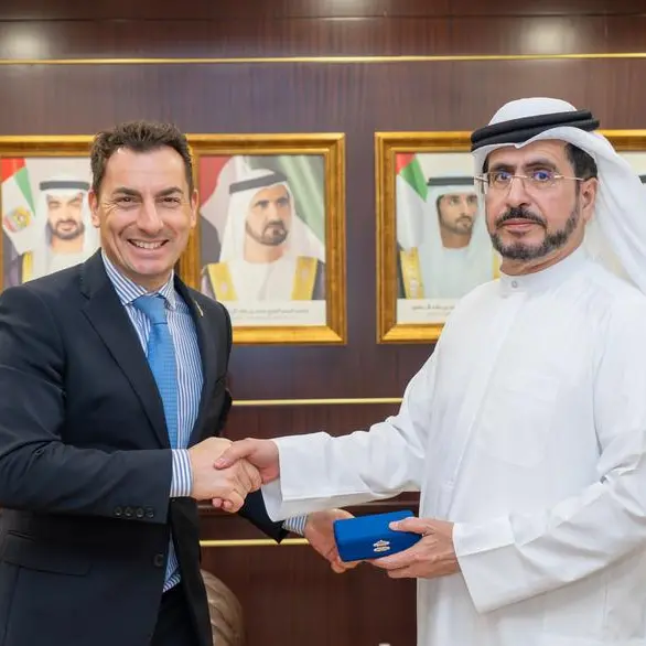
Professor Arup Dasgupta, Advisor, GIS Development announced the Geospatial Award constituted by the company during the recent Map World conference held in Hyderabad, India. Dr. Vanessa Lawrence received the award and citation from Lootah on behalf of the winners, Ordnance Survey of Britain.
The second GIS Students Educational Forum, participated by around 250 students from schools and centres of special needs children all over the Arab world is another highlight of the event, where drawings of students have been put on display. Organized by the Dubai GIS Centre, the forum aims at spreading and enhancing knowledge of maps and geospatial technologies.
The Geospatial Executive Leadership Forum is also being held along side the event with the theme "GeoSpatial Enterprises." Personalities from leading organizations from the geospatial industry and academia are addressing the participants on project management, leadership challenges and various successful business development strategies.
Map Middle East 2007 is also hosting an exclusive conference on Remote Sensing and Photogrammetry under the umbrella of the International Society of Photogrammetry and Remote Sensing.
A Round Table Discussion on Spatial Data Infrastructure (SDI) will review the status of SDI activities within the various organizations using Geo-information on local and national levels.
Different seminars held as part of the event cover the ongoing construction boom, growing demands for oil and gas and the geospatial world moving towards open source in terms of software/data and standards.
Managers and research professionals from the government sector involved in planning, developing and managing projects; directors and corporate executives interested in acquiring leadership knowledge and practical skills; human resources professionals entrusted with the development of leaders within their organizations; academicians and researchers dedicated to advancing leadership studies in higher education; specialists in leadership assessment; developers of training simulation models; illustrators of multi-media activities and graduate students pursuing a major focused upon leadership studies are expected to attend the event.
-Ends-
For further information please contact:
Ismail Meladi
Media Section
Public Relations and Organisations Department
Tel: 04-2064657, 050-6341075
Fax: 04-2232188
PO Box: 67
Website: www.dm.gov.ae
Email: ipparambil@dm.gov.ae
© Press Release 2007