PHOTO
Dubai, United Arab Emirates - PlanRadar, one of the leading digital construction, real estate and facilities management platforms, announces the upcoming AI-powered ‘SiteView’ feature, enhancing the platform's already robust documentation, communication and reporting capabilities. SiteView empowers users to capture 360° imagery of a project while walking the site, with the images automatically mapped onto a 2D plan, creating a detailed visual record of activity across every stage of the build.
Group Co-CEO Ibrahim Imam noted, “This feature’s a game changer for PlanRadar users, combining the easy to use experience with the highest levels of accuracy, making it possible to achieve complete visual as-builts and field, progress, and photo documentation, in place of taking thousands of photos. In addition with our core documentation, communication and ticketing platform, SiteView means anyone working on a project can now easily go back and look ‘behind the wall’ to see exactly what was built or installed, often reducing rework.”
While powered by cutting-edge technology, the simple solution means construction teams can walk a site with a 360° camera attached to a helmet, and SiteView does the rest. Reality capture images are automatically transferred from camera-to-app and ready to review in PlanRadar shortly after a site walk is completed, aligning the path walked onto the 2D plan. This provides a level of efficiency that makes it easy to document visual ‘as-builts’ in minutes, as well as quickly maintain any visual site documentation required.
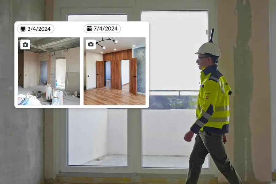
Additionally, a compare feature makes it easy to view images captured on two dates side-by-side during the build to see progress and spot any deflections.
Clemens Hammerl, Chief Product Officer, comments, “SiteView reduces on-site inspection time and speeds up team collaboration, allowing a complete view of the site, even when working remotely. 360° photographic images provide all the documentation needed to see what has happened, delivering complete project transparency. With minimal training required, users simply set a starting position on a 2D construction plan within the PlanRadar mobile app, walk the site, and press stop when finished; our sophisticated algorithms take care of the rest.”
SiteView uses SLAM technology (Simultaneous Location and Mapping), the same tech used to power driverless automobiles, to survey unknown environments while simultaneously moving through them. It operates by estimating the path of the site walker on a digital construction plan, with algorithms constantly aligning sequential data to determine position and path. The path is then aligned to the plan, using AI-powered computer vision algorithms, which integrate depth estimation and accurate localisation.
Crucially, it provides project teams with a detailed, 360° overview of activity and progress, all within the easy-to-use interface of PlanRadar’s platform. The addition of SiteView adds another layer of functionality to PlanRadar, which already includes document management, reporting and integration features, enabling customers to connect all project processes in one place.
With a comprehensive view of works available throughout each phase of the build, all project stakeholders can experience full transparency of activities. This not only helps prevent miscommunication but also mitigates potential disputes.
The upcoming launch is just the beginning for SiteView, with ongoing updates to follow, including BIM integration, and the ability to link to Tickets on the 360° images.
-Ends-
About PlanRadar
PlanRadar is an award-winning, digital SaaS field management platform for documentation, task management and communication in construction, facility management and real estate projects. The platform operates across the globe, currently in over 75 markets. PlanRadar digitises all daily processes and communication across real estate and construction. The platform connects all project stakeholders and provides real-time access to valuable project data, enabling teams to increase quality, cut costs and realise work faster. The easy-to- use platform adds value to every person involved in a building’s lifecycle, from contractors and engineers to property managers and owners, with flexible capabilities for all company sizes and processes. Today, over 150,000 professionals are using PlanRadar to track, connect and solve issues on- and off-site. PlanRadar is currently available in more than 25 languages, and can be used across all iOS, Windows and Android devices. Headquartered in Vienna, Austria, PlanRadar has 16 offices across the globe.
Contact: info@planradar.com
Website: www.planradar.com