PHOTO
The system reflects the Municipality's keenness to ensure the values of innovation week initiative
Abu Dhabi City Municipality - 24 November 2015:
On the occasion of launching Innovation Week, and out of the municipal system's keenness to ensure innovation and realize the objectives & values of this pioneering initiative, Abu Dhabi City Municipality announced a unique innovative buildings data management system. The Department of Municipal Affaires (DMA) decided to generalize the system all over its affiliated municipalities i.e. Al Ain Municipality and Western Region Municipality.
HE Musabbah Mubarak Al Murar, Acting General Manager of Abu Dhabi Municipality, paid tribute to the effective, pioneering and trendy ideas launched by His Highness Sheikh Mohammed bin Rashid Al Maktoum, Vice President and Prime Minister of the UAE and Ruler of Dubai. Al Murar said "These initiatives trigger our minds to generate innovative and creative ideas to leverage public performance and offer premium services commensurate with the needs and aspirations of the community. This distinctive initiative will also unleash our energies and encourage distinguished ideas & initiatives that will achieve the desired excellence at all levels."
His Excellency added: "Allocating a week for innovation by His Highness Sheikh Mohammed bin Rashid reflects clearly the wisdom of our leaders, and their commitment to attach top priority to development and renovation in order to carve a nifty for ourselves among advanced nations. This key target stems from the government's efforts to ensure superior quality of life, offer ultra-modern services that measure up to the current requirements and the strategic objectives of the UAE government aimed at achieving advanced growth and development rates.
Al Murar further added: "The Municipality, as a service entity, capitalizes on these wise directives and distinguished initiatives to draft plans aimed at activating innovative potentials among all municipal employees, besides providing the basis that enable us offer competitive services and establish key projects that contribute to furthering sustainable development drive at all levels.
"We believe in the importance of creating competitive advantages that render us as pioneers in this field and we also believe that innovation is one of the key methods to enhance our competitive advantage, therefore we strive to adopt this approach of creative thinking to realize our objectives. Undoubtedly, this initiative will contribute to stimulating innovators and inventors in various municipal sectors as well as other institutions. Innovation will nurture a knowledge society and cadres capable of creating new, unique and innovative ideas, which will uplift performance and provide sustainable alternatives for comprehensive development."
His Excellency added: "The values stated in the slogan launched by His Highness, Vice President of the UAE 'Innovation is not an option but a necessity,' reaffirms our government's commitment to press ahead with ensuring the highest global competitiveness edge in innovation, and provide modern alternatives to rank the UAE high among developed countries. It is an opportunity to rearrange our ideas and utilize these values & directives to move towards broader horizons to uplift performance, provide appropriate solutions and support sustainable development projects that achieve the interests of citizens and the nation.
"The Municipality is proud to launch pioneering programs and initiatives at regional and global levels, as evidenced by the buildings data management system, which reflects this drive. Such innovative output was initiated by qualified and creative municipal cadres, where the GIS Section, at Spatial Data Division has designed the Buildings Data Management System in order to provide 3-D geographical data that includes engineering details and related information for all buildings in Abu Dhabi so as to issue ownership certificates for all types of property units. This data can also be used in many applications by different entities such as Tenancy Contract Attestation System "Tawtheeq", Civil Defense, planning urban and environmental studies and addressing systems, among others," elaborated Al Murar.
Engineer Khalfan Sultan Al Nuaimi, Acting Executive Director of Town Planning Sector explained that the new system, which is considered a unique achievement by all means, is made up of many components, including:
1. Buildings Layout Standard Specifications: These include drafting buildings standard specifications layout which shall be submitted to the Municipality's Building Permits Division by the consultants. The file must be submitted in AutoCAD Format for each floor of the building. The standard specifications file shall illustrate in details the drawing method and descriptive data (such as building type of use, units, spaces, floors heights, etc. (which must be included in the AutoCAD file). These standard specifications were published, and consultants & contractors were trained and provided with examples and tools that enable them to audit their layouts to ensure their conformity with these standard specifications before submitting them to the Municipality.
Al Nuaimi pointed out submitting such layouts had become mandatory to obtain a building permit or building completion certificate starting since 2012. "Following these standard specifications in the building layouts submitted to GIS Section allows the automatic conversion of these layouts from AutoCAD format to geographical database. In addition, the mandatory submission of such layouts ensures the regular update of municipal buildings data."
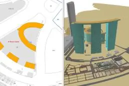
The components of the system also include the Geographical Database. A Central Geographical Database has been designed enabling the storing of building charts and descriptive data in a detailed manner offering access to various sorts of statistics & reports in a way compatible as much as possible with the drafted property ownership regulations. It must contain 3D information enabling access to the data of each property unit at any floor of any building. It also provides records about all update and adjustments made to the buildings data which have to be integrated with the other geographical database in use by the Municipality such as land plots data, and base map & layouts data which can be used by various systems such as the tenancy contracts attestation system, and real estate registration system.
The system components include auditing engineering designs. The Applications Design Team has designed a smart app comprising a number of tools including this effective tool enabling technicians at the Quality Control Team at the section to automatically & quickly audit the auto-cad drawings submitted to the Section by consultants to verify their compatibility with the standards in place. The location of the building is verified by the grid references system used by the Municipality along with the soundness of the engineering layout and the availability of the required descriptive data. Thus it is possible to assure the quality of data which will be saved in the geographical database. In case of incompatibility between designs and standards, the audit tool will generate a detailed report of errors in the drawings and forward it to the consultant for correction and resubmission.
The system includes a tool for transferring engineering drawings to the geographical database. Following the auditing of auto-cad drawings and verifying their compliance with the standards. As such this tool is used to transfer the descriptive drawings & data to the central geographical database such that it will be possible to review different types of specialist GIS software and sharing them with various bodies. This tool enables updating provisional drawings & data submitted in the As Built Permit stage, and up to the final drawings submitted to the Municipality in the issuance of the building completion certificate stage (As Built), while maintaining records for all update procedures made to such data.
The buildings spatial data management also contains a tool for reviewing buildings data which is used by directors, planners, engineers and others to review maps and buildings data saved in the geographical database in a 2 & 3 D format. It enables them access to the required reports and statistics such as the number of buildings which have a specific use within a specific area.
Al Nuaimi stated that the Buildings Data Management System had been exhibited in a number of international and local conferences concerned with the GIS such as the USA, Switzerland, and South Korea. The system was praised at a wide level as it is considered a leading global project in compiling data of local internal buildings and transforming it automatically to the GIS database through the daily building permits operations. The System, which has been accomplished by the GIS Section at the Spatial Data Division, Abu Dhabi City Municipality, on the bases of self-efforts of an internal team, provides detailed, updated and valuable data of buildings in Abu Dhabi which can be used in property registration and renting systems as well as other applications such as civil defense, urban planning, and environmental studies, thus contributing to the realization of the vision of Abu Dhabi Government and its strategic plans.
-Ends-
© Press Release 2015